

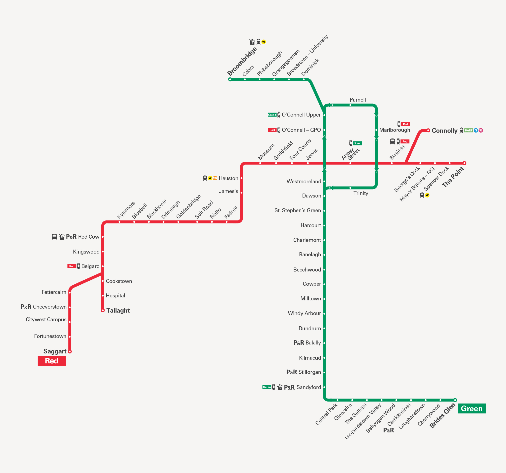
Schematic diagram of the Luas light rail network in Dublin, showing the Green Line and Red Line and their main stops, interchanges, and park‑and‑ride facilities. The Red Line is shown as a horizontal red route running roughly from west to east. At the far western end is Saggart, followed by: Fortunestown, Citywest Campus, P+R Cheeverstown, Fettercairn, Tallaght P+R, Hospital, Cookstown, Belgard, Kingswood, P+R Red Cow, Kylemore, Bluebell, Blackhorse, Drimnagh, Goldenbridge, Suir Road, Rialto, Fatima, and James’s. The line continues east via Heuston station, then Museum, Smithfield, Four Courts, and Jervis. After Jervis, the Red Line reaches the city centre interchange at O’Connell – GPO, then continues east to Abbey Street, Busáras, Connolly station, George’s Dock, Mayor Square – NCI, and Spencer Dock. The eastern terminus is The Point. Several icons along the Red Line indicate park‑and‑ride car parks (marked “P+R”), national rail connections, and bus links, especially at Red Cow, Heuston, Connolly, and The Point. The Green Line is shown as a mostly vertical green route with a city centre loop and a northern spur. At the southern end, the Green Line terminates at Brides Glen, then runs north through Cherrywood, Laughanstown, P+R, Carrickmines, Leopardstown Valley, Ballyogan Wood, The Gallops, Glencairn, Sandyford P+R, Stillorgan P+R, Kilmacud, Balally P+R, Dundrum, Windy Arbour, Milltown, Cowper, Beechwood, Ranelagh, Charlemont, Harcourt, St Stephen’s Green, Dawson, and Westmoreland. From Westmoreland the line continues into the city centre loop: it reaches Trinity, then runs north to Abbey Street and O’Connell – GPO, then further north to O’Connell Upper, Parnell, and turns west to Dominick, then University, Grangegorman, Phibsborough, Cabra, and the northern terminus Broombridge. Park‑and‑ride icons appear at Sandyford, Stillorgan, and Balally, and rail and bus interchange icons appear at Broombridge and O’Connell Upper. In the city centre, the map highlights key interchange points: O’Connell – GPO and O’Connell Upper where Red and Green Lines meet or are very close. Abbey Street and Busáras on the Red Line and their proximity to Trinity and Westmoreland on the Green Line. Major national rail and commuter rail connections are shown with train icons at Heuston, Connolly, and Broombridge. The background is light with coloured lines and clear stop labels. Each stop is marked with a small circle and its name. The words “Red” and “Green” appear at the respective line termini (Saggart for Red, Brides Glen for Green) to indicate the line colour and branch. The map is schematic rather than to scale: it focuses on showing the order of stops, interchange points between the two Luas lines, and locations of park‑and‑ride and main rail connections across Dublin.